The dark outline marked on the map defines the GCA boundary which is located on the west side of Route 1 within the Groveton community.
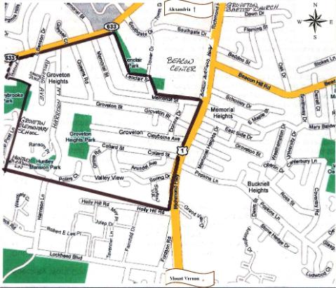
The GCA Boundary is defined with the boundaries being measured from the midlines of all outer boundary roads:
> Beginning at the intersection of the east boundary of the subdivision known as Stoneybrooke and South Kings Highway proceed northeast to Lenclair Street (about “.5” miles);
> then southeast on Lenclair Street to Memorial Street;
> then east on Memorial Street to Richmond Highway (Route One);
> then south on Richmond Highway to Holly Hill Road (about ".8" miles);
> then west on Holly Hill Road using an imaginary line across Harrison Lane, to the east boundary line of the Stoneybrooke subdivison; and
> then northeast ending at the boundary of Stoneybrooke and South Kings Hwy.
Official Streets within the GCA Boundary include (unless otherwise noted):
Amlong Avenue and Amlong Place
Arundel Avenue
Clayborne Avenue
Collard Street
Donora Drive
Grove Road
Groveton Street
Harrison Lane between South King's Highway and Polins Court
Harrison Lane between Polins Court and Lockheed Boulevard (unofficial portion of street)
Lenclair Street
Memorial Street
Polins Court
Queens Road
Ransom Place
South Benson Drive (south side of South Kings Highway only)
South Kings Highway between Lenclair and South Benson Drive
Spring Drive (note the deadend of Spring Drive past Grove Rd is county road)
Swain Drive
Tahalla Drive (unofficial street)
and
West side of Route 1 between Memorial Street and Holly Hill Road.