Friday, August 15, 2008
Highway of cool
Ever wonder what’s up with all those run-down motels along Richmond Highway? Grab your shades, crank up the Elvis and settle into your Studebaker. We’re going for a ride down memory lane.
Washington Business Journal - by Tom Shaw
Below picture:
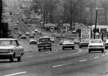
Before I-95 opened in 1958, a trip to Florida took you straight down Route 1, also known as Richmond Highway. Its two airports and small hotels and eateries were an oasis for weary travelers.
Steeped in the rich history of the colonial seaport of Alexandria and the nation’s capital, the Route 1 corridor — also known as Richmond Highway — has been the symbolic bellwether for the economic health of southeast Fairfax County.
In the glory days in the late 1940s and ’50s, Richmond Highway was beyond cool. It was a time when America had emerged from a world war, babies were being born in record numbers, suburbs were being built, people were on the move, motels were popping up and for the first time since before the Depression, there was money to be spent.
Not that Route 1 hadn’t always been important to the area. The Route 1 of the 1700s in Fairfax was known as the Potomac Path, functioning as a north-south road and an overland route for the owners of waterfront plantations, including the now-familiar landmarks of Mount Vernon, Woodlawn Plantation and Gunston Hall. The booming agriculture industry and social and commercial communication made a direct route between the growing port of Alexandria and plantations to the south essential.
In 1846, Quakers settled in the area and revitalized southeast Fairfax with agricultural advancements — ultimately making Fairfax the most productive area in Virginia. In 1857, the Potomac Path became the Accotink Parkway, a toll road, and was dubbed Richmond Highway in 1910. Finding just a two-lane dirt road, the Army paved the way to Fort Belvoir in 1918 and widened the highway to four lanes 15 years later.
Then, in 1926, the eight-mile stretch of road through Fairfax was assigned the Route 1 designation as part of a national highway running from Fort Kent, Maine, to Key West, Fla. The 2,450-mile highway uniquely captured the look and temperament of a golden era.
After World War II, the highway flourished: a neon-lit passage of motels and eateries, channeling Packards, Studebakers, Fords, Chevys and DeSotos to and from the meccas of the Sunshine State and the memorials and sites of the nation’s capital. Elvis was king and so was the automobile — with its extensive span, fins and chromed regality, motoring in cavalcade up Richmond Highway’s legendary Snake Hill. Baby boomers were just finding their legs, and a long car trip in those days — no interstate, no air conditioning — was a true test of grit and determination. The call from the back seat “are we there yet?” would chafe at the hair-raised neck of the weary fatherly driver, his fists clenching the wide steering wheel, eyes scanning the road ahead for relief.
And on the road north out of rural Virginia, relief came upon entering Fairfax County and the glow of the Route 1 corridor, with its smorgasbord of places to dine (a bathroom at last!) and bed for the night, the likes of the Dixie Pig, White Owl, Lucky Traveler, Totem Pole and the notable Penn Daw, where your room came with its own garage. These comfort stops were interspersed with souvenir, novelty and gift shops with the occasional palm reader and fortune teller.
In its heyday, the hum of automobile traffic on Richmond Highway was mixed with the buzz of air traffic overhead. Two commercial airports operated just off the highway — and just a few miles from each other. During the war, both Beacon Field and Alexandria Airport, also known as Hybla Valley Airport, turned their operations over to the Navy to train pilots. Beacon Field helped train women as ferry pilots as part of the Women Airforce Service Pilots program.
After the war, both airports opened for civilian use and, at their peak, saw considerable traffic. Alexandria Airport had four runways and four hangars while Beacon Field offered two runways and five hangars. Auburn Flying Service at Alexandria in 1945 gave flying lessons, and the Washington Soaring Club flew sailplanes from Beacon, putting on quite a show for those traveling and staying on the highway. Both airports were frequented by radio celebrity Arthur Godfrey, who learned to fly at Alexandria and kept his DC-3 at Beacon.
With the end of the ’50s came the end of Richmond Highway’s boom. Interstate 95 opened in 1958, bypassing the highway and taking the tourism industry with it. Farms nearby were bulldozed for residential development, closing both airports, Alexandria in 1955 and Beacon in 1959. What agricultural value that existed on both sides of the highway was now gone. A slump festered for many years as Route 1’s quaint neon establishments closed or barely succeeded at keeping their doors open, and people obtaining low-wage employment settled into subsidized housing along the highway. A sense of isolation prevailed as western Fairfax boomed.
But Richmond Highway did not die. In 1982, the formation of the Southeast Fairfax Development Corp. and renewed efforts by Fairfax County to bring back struggling sections of the county raised prospects of a revitalized Richmond Highway. New life has come to the highway, particularly in the last five years. Beacon Mall and the Mount Vernon Plaza now sit on Beacon Field and the Hybla Valley airport. New hotel development is picking up where the motel boom of the ’50s left off. New jobs at Fort Belvoir may bring new office buildings and residential promise. The onetime “highway of cool” is getting hot again.
Tom Shaw, a board member of the Southeast Fairfax Development Corp., is researching Richmond Highway’s history.